THE SOMERSETT SITE
An archaeological portrait of an Ulster-Scots habitation on the Maine frontier
PAMELA CRANE
The following pages are reproduced from: “1718-2018, Reflections on 300 years of the Scots- Irish in Maine”
printed following the academic conference held at Bowdoin College, Maine in August 2018.
© 2019 Maine Ulster-Scots Project and the Ulster-Scots Agency
All rights reserved. No part of this publication may be reproduced, stored in a retrieval system, or transmitted in any form or by any means, electronic, mechanical, photocopying, recording or otherwise, without the prior written permission of the publisher and copyright holder
PART 1
Forward
In 1718, a group of Ulster-Scots settlers arrived on the shore of Merrymeeting Bay, in what is now Maine. The Bay itself is a large estuary at the confluence of five rivers: the Muddy, Androscoggin, Cathance, Abagadasset, Kennebec, and Eastern Rivers. Among the new arrivals from Ulster, were Andrew and Jane McFadden. They named their new homestead “Somersett”; the landscape of the Bay reminded them of them of their former environs on the Bann River in Northern Ireland.(1) Their house at Somersett was burned four years later, during the border conflict known as Dummer’s War.
In 1675, Andrew was born on the Isle of Mull, in the Inner Hebrides of Scotland.(2) He moved to Londonderry some time before 1693, and died in Georgetown, Maine in 1753. At that time, Georgetown was of Massachusetts. In 1704, he married Jane Linsday in Garvagh. Jane, a native of Garvagh, was born in 1678.(3) She, too, died at Georgetown in 1776. Andrew and Jane had seven children: Andrew, William, Daniel, Somersett, James, John, and Thomas.
The couple was remarkable. The span of Andrew’s and Jane’s lifetimes included three seminal events: King Philip’s War; the beginning of one hundred years of warfare between the French and their Wabanaki allies and the English; the arrival of five ships carrying Ulster-Scots settlers into Boston beginning the diaspora of Ulster-Scots from the North of Ireland; and the Declaration of Independence separating the America colonies from the British Empire.
In 1718, Joseph Heath drafted a map of Merrymeeting Bay (Figure 1). Heath was a member of the Pejepscot Proprietors, a consortium of investors intent on developing the Bay after the devastation of Queen Anne’s War. The purpose was commercial; it showed the division of lots between the Proprietors on Merrymeeting Bay. Heath depicted the three homesteads lying on a point between the Cathance and Abagadasset Rivers, comprising the Somersett settlement. A cellar hole tucked into a cove, at the north end of the point, has long been presumed as the site of the McFadden homestead. Nevertheless, the McFadden family and their story remain a touchstone to the early experience of the Maine Ulster-Scots.

Figure 1
Heath Map of 1718 depicting lot divisions of the Pejepscot Proprietorship on the west side of Merrymeeting Bay and Kennebec River. The excavated site corresponds in location to the house at the south end of lot No. 6. Based on differences in script, the lot descriptions and many places were placed on the map when it was originally drafted. Over the lifetime of the proprietorship, additional notes were added. Thus, it is confirmed that a saw mill on a tributary to the Cathance River was available to provide sawn planks to the settlers, even at this early date. The description of the saw mill on the Abagadasset River, on the other hand, was not added until 1740. Most importantly, an annotation to lot No. 5 states that “McFadden & Wilson were tenants on ys [this] lot” raises the possibility that the excavated site was not that of Jane and Andrew McFaddens, but rather, one of their neighbors. Item 12631, Collection of Maine Historical Society.
A year later, Heath and Stephen Minot drew a second map (Figure 2). Minot was also a Proprietor. The purpose of the map was clearly political. At the time, England claimed the east side of the Kennebec River. The French Wabanaki claimed the west shore as their territorial boundary. The map depicts the settlers’ houses on the Bay and the Wabanaki Village at Norridgewock. Most importantly, the map also includes a description of the Norridgewock Village.

Figure 2
Heath-Minot Map of 1719 depicting Merrymeeting Bay, the Sagadahoc River (the bay’s outlet river) and the Kennebec River, as far inland as the Native village at Norridgewock. At Somersett, three homesteads were, once again, depicted. Note also, Richmond Fort just north of Garden Island on the Kennebec. This map was drafted at two distinct scales, with the one used to record Merrymeeting Bay exaggerated by a factor of 16 compared to that used to record the length of the river. Item 11979, Collection of Maine Historical Society.
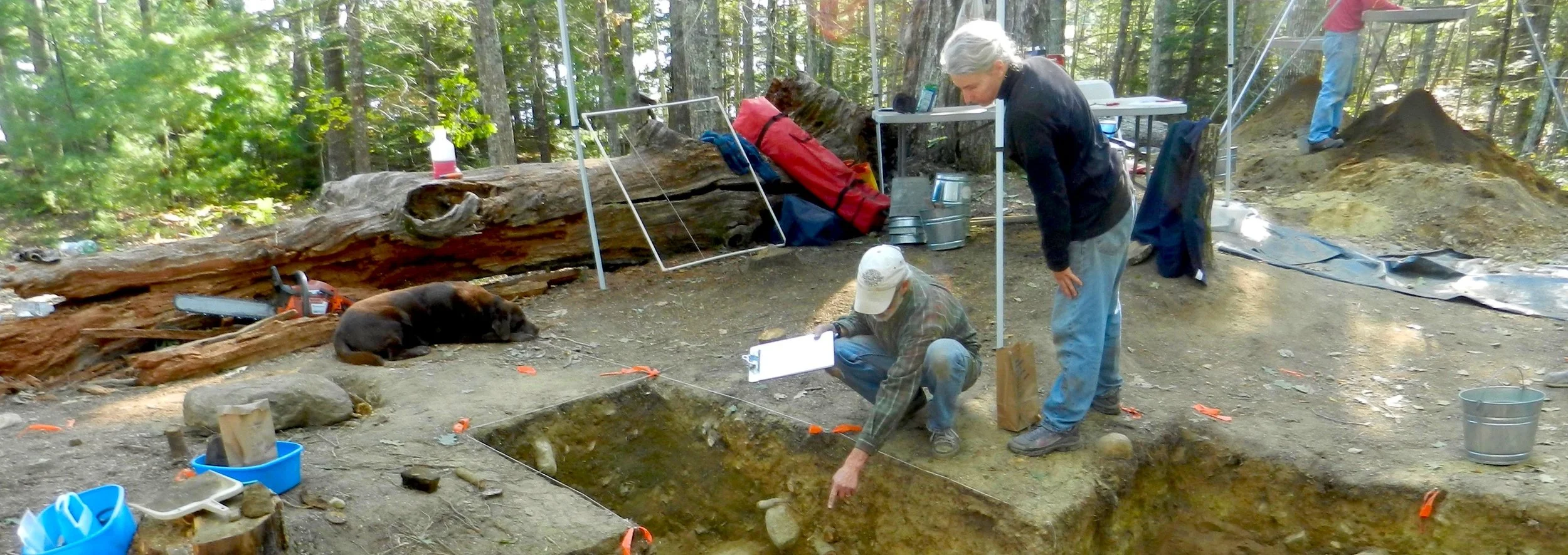
In 2012, archaeological work was initiated on a cellar hole on land owned by Bradford McFadden, a descendent of Andrew and Jane. Unequivocally, this site represents a first- generation Ulster-Scot habitation in Maine. The charred remains of what is presumed to be Andrew’s and Jane’s house lay undisturbed for 300 years. Excavations at the site have provided information on the material culture of Ulster in 1718, and the first interactions of English settlers, the newly-arrived Ulster-Scots, and the native Wabanaki.

Pamela Crane obtained a Master of Arts Degree in History from the University of Maine, and is a Level 2 Historical Archaeologist.
She has worked in archaeology for the past 30 years throughout the northeastern United States. Her thesis project concerned the historical archaeology of the Norridgewock Mission, site of a seventeenth- through eighteenth-century French Jesuit Mission and Abenaki village.
Her research interests includes New England historical archaeology, historical landscapes, ethnicity, and material culture. Currently, she is pursuing archaeological and historical work in connection with the Maine Ulster-Scots Project.

Land owner Brad McFadden shows site director Pam Crane a recent find.
The pages above are reproduced from: “1718-2018, Reflections on 300 years of the Scots- Irish in Maine”
printed following the academic conference held at Bowdoin College, Maine in August 2018.
© 2019 Maine Ulster-Scots Project and the Ulster-Scots Agency
All rights reserved. No part of this publication may be reproduced, stored in a retrieval system, or transmitted in any form or by any means, electronic, mechanical, photocopying, recording or otherwise, without the prior written permission of the publisher and copyright holder.